Reading a VNC: The Airspace Details Students Miss
By Pilot Prep
Most student pilots can tell you that a control zone needs a clearance. Far fewer can look at a patch of VFR navigation chart and say, in a few seconds, what every line, letter and number on it is asking of them.
That gap is where airspace busts start, and reading the chart is a skill the PPL Air Law syllabus tests directly.
Our guide to New Zealand airspace classes covers what each type of airspace is. This post is about the paper itself: the line styles, the label boxes, the figures people misread, what the smaller-scale charts leave out, and how to know your sheet is still telling the truth.
Read the line before the label
A VNC is built to be read in two passes. The line style tells you which family of airspace you are looking at, and the letters in the label finish the job. Read them in that order, because the line is obvious from across the cockpit and the label often is not.
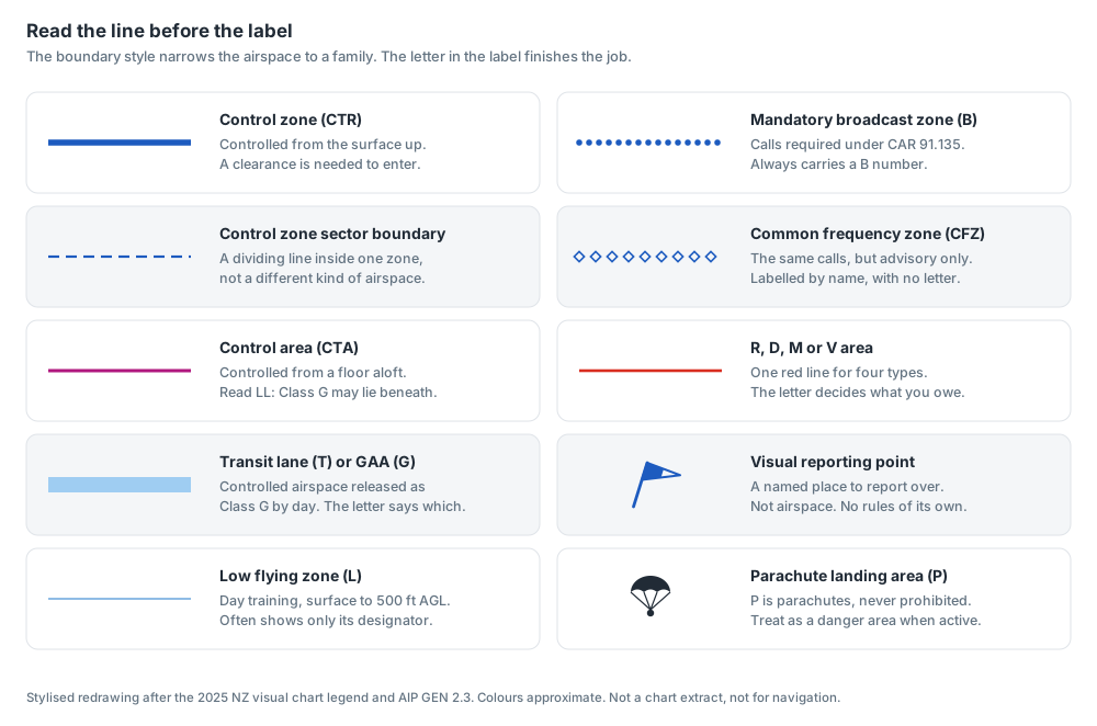
Stylised redrawing of the boundary styles in the 2025 New Zealand visual chart legend. Not a chart extract, and not for navigation.
Blue does most of the work. A heavy solid blue line is a control zone, controlled airspace that reaches the ground, and thinner blue dashes inside one are only sector boundaries. Dots, diamonds and a thin pale blue outline are the broadcast and low flying zones, covered below.
A solid magenta line is a control area, and the switch from blue to magenta is the most useful colour change on the chart. Blue means controlled to the ground. Magenta means a floor, with possibly Class G beneath it.
A broad pale blue band is either a VFR transit lane or a general aviation area. Both are pieces of controlled airspace released as Class G by day, so they share a style, and the letter T or G tells them apart.
A solid red line marks a restricted area, danger area, military operating area or volcanic hazard zone, all in the same red. The boundary only says something unusual is happening there. The letter carries the rule.
Two symbols are not airspace at all. A small flag on a slanted staff is a visual reporting point, a named place to report over, and it has no rules of its own. A parachute symbol is a parachute landing area.
The line tells you the family and the letter tells you the rule. Heavy blue reaches the surface, magenta has a floor, and red says only "special use airspace", leaving the letter to decide between permission and caution.
The label box, decoded
Every block of controlled airspace carries a small box in the colour of its boundary, written in a fixed order.
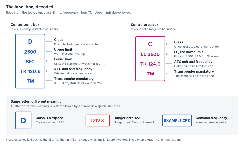
Fictional boxes laid out the way the chart lays them out. The unit, frequencies and area number are invented.
Read a control zone box from the top down. The large letter first is the class, C or D, always in the same place. Then come the vertical limits, upper above lower, so a zone from the surface to 2500 ft shows 2500 over SFC. Then a short abbreviation for the ATC unit with its frequency, and finally, if it applies, TM.
A control area box gives the class, then its floor marked LL for lower limit, then the frequency and TM.
One reading trap is worth fixing now. A single large letter is a class. A letter followed by a number is a special use area. So D in a control zone box means Class D and a clearance from ATC, while D123 would be a danger area that needs no approval from anybody.
TM is the easiest thing in the box to read past. AIP ENR 1.4 says transponder mandatory airspace is marked TM in the box on the VNC and VPC. In transponder mandatory controlled airspace, CAR 91.255 requires ADS-B equipment and CAR 91.247 requires it to be transmitting from the moment you move under your own power until you stop. TM never replaces the clearance that CAR 91.245 still requires.
The frequency in a control area box is the one to call to climb up into that step. If you are flying underneath it in Class G, you owe that unit nothing.
Some special use areas carry little more than a designator, and a low flying zone can appear as an outline and its L number alone. The full limits and who administers each area live in the New Zealand Air Navigation Register.
Floors and tops: the number people misread
Reading both figures on every box is the easy part. Reading them correctly is where it goes wrong.
The first misread is swapping the two figures. The upper limit sits on top, and a hurried glance at "2500 over SFC" can come away as "starts at 2500". For a control zone that cannot be right, because a CTR always starts at the surface, which makes a handy sanity check.
The second is units. Limits are in feet AMSL unless stated otherwise, and New Zealand only uses flight levels from the transition level of FL150 up, so anything a VFR pilot meets below that is an altitude on QNH. The exception is a low flying zone, which runs from the surface to 500 ft AGL under AIP ENR 5.3, a height above the ground.
The third is LL CA at the top of some zones. It means the zone runs up to the lower limit of the controlled airspace above it. When the steps overhead sit at different heights, that top changes as you move across the zone, so you have to find the step you are actually under.
The fourth is forgetting that special use airspace has floors and tops too. The Taupo mandatory broadcast zone runs from 3000 ft to 6500 ft, so an aircraft at 2500 ft beneath it is not inside. A restricted area with a 2000 ft top is not in your way at 3500 ft.
The last is a planning trap. A control area floor such as 3500 or 4500 ft can be the very figure the VFR cruising levels in CAR 91.313 hand you, so the level you would naturally pick can be the floor itself. Plan to be clearly under it, not on it, with margin for a slightly wrong QNH.
Restricted, danger and military areas
All three share the red line, so the letter is everything: R restricted, D danger and M military operating area, with the register's NZ prefix dropped on the chart.
R and M are about permission. CAR 91.129(a) says you must not operate in a restricted area without the approval of its administering authority and compliance with its conditions, and CAR 91.133 applies the same test to a military operating area, which AIP ENR 5.2 says needs entry approval in the same manner as a restricted area. AIP ENR 5.1 adds a line worth memorising: you must not enter an active restricted area in anticipation of the approval arriving.
D is about judgement. CAR 91.129(b) lets you into a danger area once you have determined that the activity will not affect the safety of the aircraft. There is nobody to ring for permission, so the decision is entirely yours.
ENR 5.1 adds the subtle point. Special use airspace does not change the class of the airspace underneath, it sits on top of it, and its rules are considered first. An active restricted area inside a control zone is not opened up by an ATC clearance. You may need both.
Two more letters belong to the same family. V is a volcanic hazard zone, and the circle on the chart is drawn for volcanic alert level zero or one, at a 3 NM radius. If the alert level rises the zone is redefined by NOTAM, reaching 16 NM and FL330 at level three, so the printed circle is the smallest it ever gets. And P is never prohibited. New Zealand has no prohibited areas, so P is a parachute landing area, treated as a danger area when active.
R and M need the administering authority's prior approval when active (CAR 91.129 and 91.133). D needs only your own determination that it is safe (CAR 91.129(b)). An ATC clearance does not open an active restricted area inside controlled airspace.
Broadcast zones: dots and diamonds
Dots and diamonds look alike at a glance, but one is a rule and the other a recommendation.
A line of solid dots is a mandatory broadcast zone, and it always carries a B number. Its box gives the limits, when it is active (H24 or by day, for example), the frequency and a reporting interval such as "10 min". CAR 91.135 makes the calls compulsory at entry, when joining a circuit inside the zone, before entering a runway for take-off and at that interval, with a listening watch and your landing or anti-collision lights on if fitted. AIP ENR 1.1 adds a report when you leave.
A line of hollow diamonds is a common frequency zone, and AIP ENR 5.3 says its calls are encouraged but not mandatory. On the chart a CFZ is labelled by its name rather than a letter. The legend happens to key it with a C, so do not let that persuade you a CFZ is Class C.
The two often sit together, sometimes with control area steps overhead, so one patch of chart can ask for a compulsory call, an advisory call or a clearance depending on where and how high you are. Step through the calls the rule demands below.
Loading simulation
Transit lanes and general aviation areas
Both share the broad pale blue band, and both are, in AIP ENR 5.5's words, part of a CTR or CTA released as Class G airspace during daylight hours.
A T is a VFR transit lane. While it is active you may enter and operate in it without a clearance or reference to ATC, but it is a precise box. Most lane tops are 1000 to 1500 ft, and climbing through the top or drifting out of the side puts you back in controlled airspace with no clearance.
A G is a general aviation area, and here the chart cannot tell you the thing that matters most, which is whether it is open. Under CAR 91.139 you may use one only by day and only when it is active, and the register says which of three methods applies: active all day, on notification to ATC, or on ATC approval, which is the largest group. If you did not request the activation yourself, ENR 5.5 says to confirm with ATC that it is active.
Inside an active GAA you need not fly the VFR cruising levels of CAR 91.313, which is what makes it useful for manoeuvring practice, and powered aircraft squawk 1400.
The trap with a T is the box. The trap with a G is assuming it is open because it is printed.
What the smaller-scale charts leave out
AIP GEN 3.2 is blunt about what each visual chart gives you.
| Chart | Scale | What it shows |
|---|---|---|
| VPC | 1:1,000,000 | All designated and special use airspace, but not low flying zones or visual reporting points |
| VNC | 1:500,000 | Selected aeronautical information. Low flying zones and visual reporting points still not shown |
| VNC | 1:250,000 | Complete aeronautical information |
| VNC | 1:125,000 | Complete information for the Auckland, Christchurch, Queenstown and Manawatu terminal areas |
The line to fix is where "complete" starts. The VPC and the 1:500,000 VNC both leave out low flying zones and visual reporting points. A controller may ask you to report at a point that is simply not printed on your 1:500,000. And a low flying zone you cannot see is one you might wander into at low level, when CAR 91.131 restricts who may operate in one and requires a briefing from its using agency.
So the VPC is for the big picture, and near a terminal area, a control zone or a reporting point you want the 1:250,000 or 1:125,000 in your hand.
Scale has one more trap. A 1:250,000 chart is the larger scale, because one part in 250,000 is a bigger share than one in 500,000. Measure on it with the 1:500,000 side of your ruler and every distance doubles, along with every time and fuel figure built on it.
Switch between the scales below over the same corner of a terminal area and watch the low-level detail appear.
Loading simulation
Keeping your VNC current
A chart shows the airspace as it was on its effective date. Everything since has to come from somewhere else.
Start with the sheet itself, which prints its effective date beside the chart title. AIP GEN 3.2 sends you to the permanent AIP Supplement Nr 1, the AIP Publications Status Checklist, for the dates of the visual charts in force. In the 2026 series that is SUP 1/26. If the date on your chart matches the checklist, the edition is current, and the checklist also shows when the next one is due.
A current edition can still need correcting. The supplements include a list of amendments to hand-annotate onto your VNC, such as a runway now shorter than printed or a reporting point the sheet does not show. Your printed chart stays in use, marked up by hand.
Charts are updated with the AIP amendment cycle, and GEN 3.2 says an operationally significant error on a published chart is corrected by NOTAM, with a supplement if necessary. Under ENR 5.1, temporary restricted and danger areas also arrive by supplement or NOTAM, and a volcanic hazard zone grows by NOTAM. None of that is on the paper.
That is why CAR 91.221 asks for charts in current and appropriate form: the right edition, marked up, read alongside a briefing for the day you fly. And AIP material takes effect at 0000 local time on its effective date, so a new edition bought early is not yet in force.
Why reading the detail matters
You can answer plenty of airspace questions knowing only that Class D needs a clearance. The harder ones are chart questions in disguise: is the D in this box a class or an area, does this zone start at the surface or at 3000 ft, is this sheet still current.
The same skill keeps you legal in the air. Read the line, then the letter, then both numbers, then the date. Do it in that order every time and the chart stops being decoration and becomes the plan.
Try free practice exams on airspace and charts, with full explanations, and see how much of this you can already read. When you want the whole picture, the PPL Air Law course teaches every part of this, with interactive charts you can explore.
Sources and further reading
- AIP New Zealand GEN 2.3, chart symbols, including the airspace legend
- AIP New Zealand GEN 3.2, aeronautical charts: chart scales, content, maintenance and the Supplement Nr 1 status checklist
- AIP New Zealand ENR 1.4, airspace classification and transponder mandatory airspace
- AIP New Zealand ENR 5.1 and ENR 5.2, restricted, danger and military operating areas
- AIP New Zealand ENR 5.3, mandatory broadcast, common frequency, low flying and volcanic hazard zones
- AIP New Zealand ENR 5.5, general aviation areas and VFR transit lanes
- AIP New Zealand and the Air Navigation Register, published free at aip.net.nz
- Civil Aviation Rules Part 71, Designation and Classification of Airspace
- Civil Aviation Rules Part 91, General Operating and Flight Rules, including 91.129, 91.131, 91.133, 91.135, 91.139, 91.221, 91.245, 91.247 and 91.255